Add Row
Add Element
update
High Desert Thrive News
update
Add Element
  • Home
  • Categories
    • Local News
    • High Desert Lifestyle
    • Home Services
    • Restaurants
    • Adventure Trails
    • Wildlife Wonders
    • Climate Insights
    • Health
  • Featured
August 31.2025
2 Minutes Read

Extreme Heatwave Expected in British Columbia: What's Behind This Unusual Weather Pattern?

Weather map indicating British Columbia heatwave with vivid temperature anomalies.

Understanding the Unusual Weather Patterns Affecting British Columbia and the Pacific Northwest

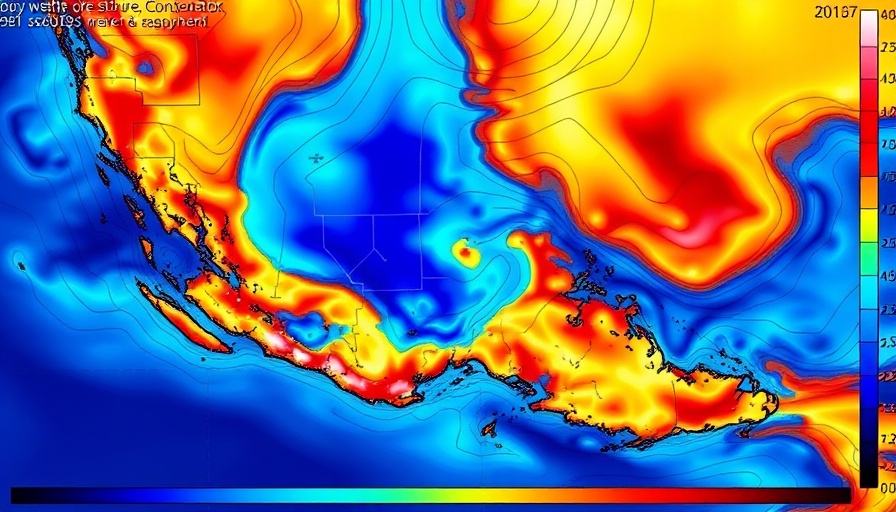
As August comes to a close, meteorologists are observing a unique weather pattern that is poised to bring an extreme heatwave to British Columbia and the Pacific Northwest (PacNW) as the summer of 2025 transitions into fall. This year, the heat will extend across the border, with lesser heat felt in California (CA), resulting in an atypical climate scenario that has left many wondering about the causes and potential consequences.

Summer 2025: A Tale of Contrasts Across California

In stark contrast with the usual scorching summers of California, 2025 has seen varied weather across the state. While the California interior has registered higher-than-average temperatures, particularly in desert and mountain areas, the coastal regions experienced a surprisingly cool summer, marking one of the coldest Julys in over 30 years. This divergence highlights an essential climatic principle: rising long-term temperatures do not preclude unusual seasonal coolness, especially in coastal areas influenced by oceanic patterns.

Precipitation Patterns and Their Effects

While the heatwave is noteworthy, so too is the precipitation—or lack thereof. Most of the West, including core monsoon regions, experienced a particularly dry summer. Recent rainfall attempted to alleviate some drought conditions, but overall, the weather has remained quite barren relative to historical averages. Only a handful of intense thunderstorms provided brief reprieve in the mountains and deserts, indicating a patchwork of weather conditions rather than a consistent trend.

Future Predictions: What's Next for the West?

Looking ahead, experts anticipate that this unusual heatwave may not only challenge our immediate comfort but may also have longer-term effects on wildlife and human lifestyles in these regions. Heatwaves can exacerbate drought conditions, lead to increased wildfire risks, and have wide-ranging impacts on water resources and agriculture—a critical concern for much of the Southern West.

Understanding Heatwaves and Their Implications

The current weather phenomena remind us that climate variability is not merely a matter of heating but a complex interplay of various atmospheric elements. While immediate concerns focus on soaring temperatures, it’s essential to acknowledge their implications on health, local ecosystems, and the infrastructure designed to withstand seasonal variations.

Taking Action: What Can You Do?

For residents in heat-prone areas, understanding the upcoming weather patterns can be crucial for preparation. Simple actions such as staying hydrated, preparing homes for temperature fluctuations, and being proactive about community wildfire prevention can create safer living environments during this period of change. Additionally, engaging in local conservation initiatives can assist with maintaining healthy ecosystems amidst shifting weather patterns.

In closing, the extreme heat anticipated for British Columbia and the PacNW, contrasted with California’s cooler regions, serves as a critical reminder of the complexities of our climate. With appropriate awareness and response strategies, communities can navigate these challenges and safeguard their health and environments against emerging climatic threats.

Climate Insights

1 Views

0 Comments

Write A Comment

*
*
Related Posts All Posts
10.09.2025

Hurricane Priscilla's Remnants to Bring Significant Rain to Southwest

Update What’s Impacting the Weather in the Southwest?As the remnants of Hurricane Priscilla swirl off the Pacific, regions in the Southwest, particularly Southern California, are bracing for a wave of rainfall and thunderstorms. Starting Thursday through the weekend, moisture will sweep into Southern California, potentially bringing heavy rainfall to the area.This weather shift comes after a notably warm September, with California experiencing milder than usual temperatures. High humidity, coupled with unpredictable rainfall, has provided a silver lining in fire hazard mitigation across the state. Atmospheric conditions have helped keep fire risks low, but precaution is vital as storms approach.Late-Season Rain: A Double-Edged SwordThe arrival of precipitation in Southern California is part of a larger weather pattern that has exhibited unusual characteristics this season. Farmers and local residents may find the rains welcome; however, as seen in previous events tied to moisture from tropical storms, these systems can easily tip into dangerous territories. Flash flooding remains a possibility as these storms move through the region, which could cause complications in flash watershed areas.In regions like Phoenix, Arizona, assessments indicate potential rainfall up to 1.25 inches, easing into the area by Friday. The expected steady trickle of rain, rather than sudden downpours, should mitigate flash flooding risks associated with sudden deluges. Despite careful measurements, even gradual storms can lead to localized flooding, particularly in areas unaccustomed to substantial moisture.Climate Context: Why This Matters NowThe unusual September warmth across California and parts of Nevada has highlighted ongoing shifts in climate patterns driven by warming ocean temperatures. Studies indicate that the current marine heatwave is influencing atmospheric conditions, creating environments conducive to rain events that many attributed to seasonal shifts. This especially impacts local agriculture and public safety.As we witness these systems moving along the coast, it’s essential to keep an eye on the broader implications of prolonged rainfall patterns. While much of Southern California is not expected to face the shocking intensity of previous storms, cumulative rain here could lead to resource management and urban drainage challenges, raising questions on preparedness for potential future extremes.Looking Ahead: What’s Next in Weather Patterns?Forecasts suggest that the wet weather isn’t going to dwindle just yet. Meteorologists anticipate that additional tropical systems may develop, fuelling ongoing rainfall opportunities in the next week. Communities should prepare for an active weather period as moisture flows in from the remnants of Priscilla, indicating potential further storms approaching from the south.As we consider the current landscape of the Southwest’s weather, proactive engagement with local forecasts and readiness for unpredictable weather can enhance safety and comfort for residents. The convergence of tropical moisture patterns calls for monitoring and community awareness as serious consequences can arise from even staggered rainfall.Taking Action: Stay Informed and PreparedFor residents in the Southwest, remaining vigilant about weather conditions is crucial. Sign up for local alerts and keep track of updates from meteorological services as new information emerges about approaching weather systems. While we have seen beneficial rain, it is essential to respect the power of these weather patterns and ensure safety measures are in place. Increased rainfall may ease fire threats, but it also brings new risks that require community preparedness.

09.28.2025

Exploring Big Eddies: Understanding Wind Patterns That Shape California's Coast

Update Understanding Big Eddies: The Phenomenon Behind the Wind Have you ever wondered what causes those strong winds that whip through the California coast? On a recent Saturday, we saw a perfect example of how weather patterns, particularly the influence of Big Eddies, shape our local climate. This fascinating atmospheric phenomenon is not just a meteorological curiosity; it plays a crucial role in how winds, especially from the Gulf of Alaska, manifest along our coastline, affecting everything from kite flying to boat navigation. The Anatomy of an Eddy The genesis of our featured eddy began with a storm system emerging from the Gulf of Alaska, which eventually pushed high-pressure systems into the Pacific Northwest. This chain reaction caused a low-pressure area to bulge over a wide swathe of the coast—from Sacramento through Bodega Bay down to Southern California. This unique setup creates a pressure gradient that stirs up the winds, allowing Big Eddy to stretch its influence from San Diego all the way to Mendocino. Wind Patterns Explained As the south coast winds approach critical gaps, like the Hwy. 92 and Golden Gate, they undergo fascinating changes—they curve and gain speed, propelling towards the Sacramento pressure gradient. This results in varied wind speeds across different locations; for instance, at the North Tower, wind speeds soar in the low 20s, while less exposed places like Point Blunt see a decrease to the upper teens. Interestingly, this creates a complex tapestry of wind strength and direction, which can hugely affect local outdoor activities. Why Big Eddies Matter for Local Communities For adults in the high desert area, understanding these weather patterns can make a significant difference. Not only does it enrich our awareness of climate dynamics, but it also has practical implications for daily life—from planning outdoor events to managing agriculture. As climate issues increasingly threaten local environments, recognizing how weather phenomena like Big Eddies influence conditions helps communities adapt and thrive. Looking Ahead: The Future of Wind Patterns As our climate continues to evolve, keeping an eye on systems like Big Eddies will be vital. Enhanced knowledge of these wind patterns can empower our community to take proactive steps in addressing potential climate challenges. By coming together, sharing information, and adapting our activities in response to these natural phenomena, we can foster a stronger relationship with our environment. A Call to Action As you embark on your next outdoor adventure or community gathering, take a moment to appreciate the hidden forces that make our unique weather possible. Share this knowledge with others, explore local climate events, or even contribute to discussions about weather patterns in your area. Together, we can create a more resilient community in the face of a changing climate.

09.22.2025

Discover the Impact of Late-Season NW Winds on California's Coast

Update Understanding Late-Season Northwest Winds in CaliforniaAs summer gives way to autumn, the dynamics of wind patterns along the West Coast become increasingly intriguing, especially for those living in the high desert eager to understand the climate's nuances. The late-season Northwest (NW) winds bring a blend of meteorological factors, which create a unique experience for residents and wind enthusiasts alike.The Impact of Cold Fronts on Coastal WindsThis week, a distant cold front is exerting its influence on local winds, compacting the NW ocean winds along the coast. This compaction is crucial for understanding how local wind patterns develop. As the cold front moves closer, it alters the pressure systems, leading to notable changes in wind behavior across significant launch sites. The winds aloft, measuring approximately 1000 feet above ground, are expected to generate gusty conditions along popular spots such as Waddell and Bodega Bay.Cumulative Effects of Pressure GradientsAs the morning fog begins to lift, the difference in pressure between the coastal region and areas further inland, like Bakersfield and Stockton, plays a pivotal role. This gradient intensifies the winds, producing strong gusts that can reach upper teens to low twenties according to recent observations. Launch sites like Crissy Beach and Coyote Point are set to experience the brunt of these gusts, presenting both challenges and exhilarating opportunities for adventurers.Gearing Up for Windy AdventuresFor residents and adventurers in the high desert, these weather fluctuations signal a perfect time to explore outdoor activities that take advantage of the winds. The anticipated strong gusts at local launch sites can lead to thrilling experiences in wind sports such as kitesurfing and windsurfing. Understanding these wind patterns can prepare enthusiasts to maximize their time on the water while remaining safe.The Human Connection to Climate PatternsBeyond the technicalities, the changing winds also reflect broader climate issues that impact our local environment. Everyone has a role to play in understanding these patterns and their effects. Engaging with local weather initiatives can strengthen community bonds and foster a collective approach to addressing the emerging climate challenges that affect us all.Join the ConversationAs the winds shift, so too can our perceptions of the climate around us. Keep track of these forecasts, and connect with other residents interested in the local climate issues. By sharing experiences and stories, we can cultivate a deeper understanding of our ever-changing world – one gust at a time.

Terms of Service

Privacy Policy

Core Modal Title

Sorry, no results found

You Might Find These Articles Interesting

T
Please Check Your Email
We Will Be Following Up Shortly
*
*
*